A lake’s regular sedimentation patterns can refine earthquake-timing estimates for scientists, writes guest columnist Sylvia Nicovich.
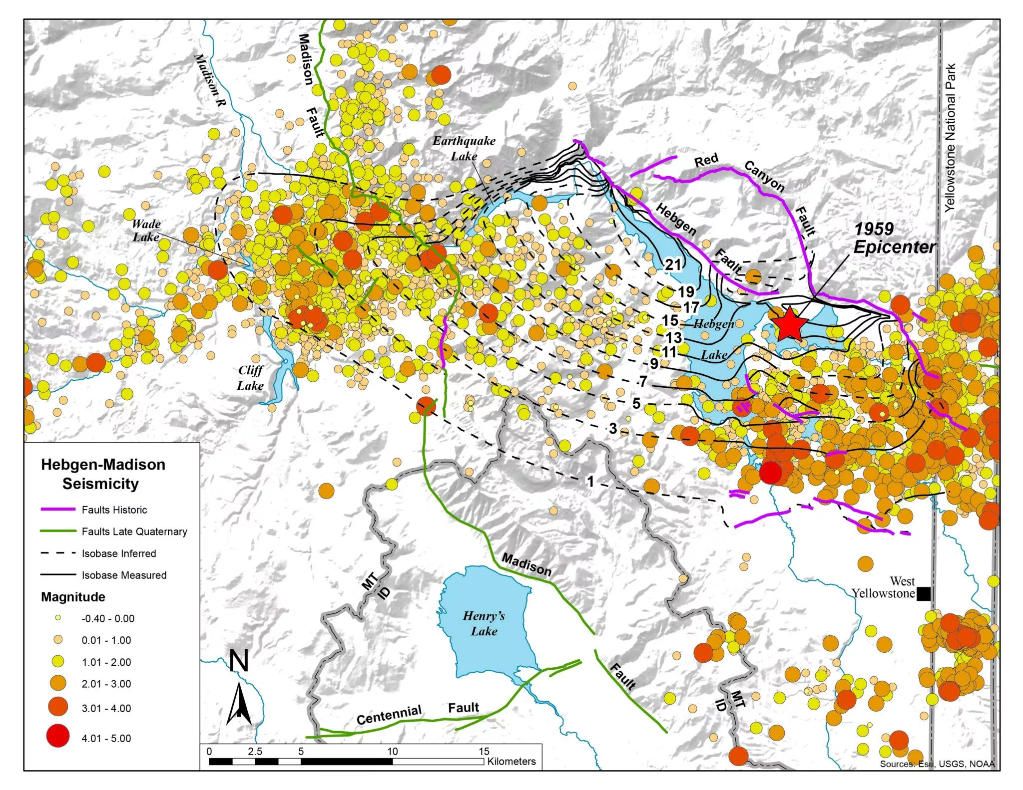
WEST YELLOWSTONE – In the summer of 1959, the west Yellowstone region experienced one of the largest Rocky Mountain earthquakes in instrumented history.
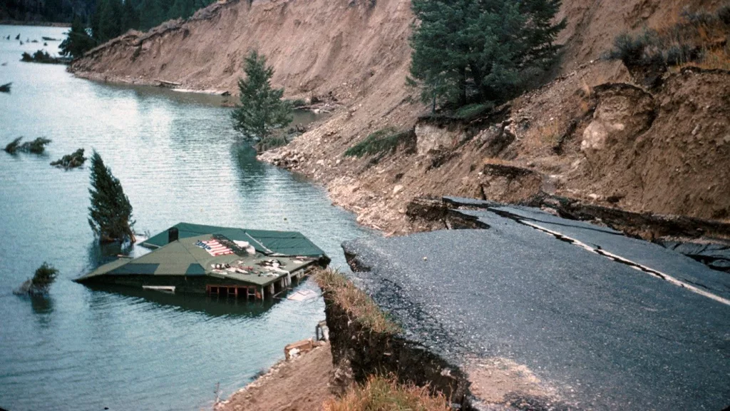
The M7.3 Hebgen Lake earthquake caused severe damage and killed 28 people, most notably due to a landslide into a campground in Madison Canyon downstream from Hebgen dam. Here, roughly 30 million cubic meters (imagine 30 million washing machines!) of material from the north-facing slope of Madison Canyon came crashing down in the night, burying the campground and damming the Madison River to form Earthquake Lake.
We have learned a lot from destructive historic earthquakes like that at Hebgen Lake. The evidence it left on the landscape, such as fault scarps (steep breaks in slope where vertical displacement occurred along the fault), are especially important for understanding prehistoric earthquakes.
The study of such earthquakes, called paleoseismology, can help to better characterize earthquake-producing faults by providing information about the recurrence and magnitudes of past earthquakes.
Lakes are becoming increasingly popular in paleoseismic studies. Their regular sedimentation patterns can refine earthquake-timing estimates and can potentially capture earthquakes that may not have ruptured the ground surface but still produced substantial ground shaking.
This subdiscipline is called lacustrine paleoseismology and has been typically practiced in deep, steep, glacially influenced lake systems, like those along the Teton Range to the south.
Because the impacts of the Hebgen Lake earthquake have been documented, a thorough understanding of how this earthquake affected nearby lake basins could teach us to interpret hidden earthquake records in different types of lakes — especially in shallow lakes with gentle slopes, like Henrys Lake just west of West Yellowstone in Idaho.
In the late winter of 2023, our team from the U.S. Geological Survey Geologic Hazards Science Center set out to Henrys Lake with the hypothesis that this shallow lake basin contains evidence of the 1959 Hebgen Lake earthquake. Because Henrys Lake is only about about 15 miles from the earthquake epicenter and therefore experienced strong to very strong shaking, it is fair to assume that lake sediment may have been disturbed.
To test this hypothesis, we extracted seven sediment cores, each about a little over 6 feet long, along an east-west transect across Henrys Lake during winter 2023. A benefit of working on lakes in the winter is that standing on solid (icy) ground can offer a steadier working environment than trying to collect sediment cores from a boat. Just like ice fishing, we used an ice auger to make a hole through the frozen lake surface and plunged the coring device into the water and then into the lake floor, keeping it leashed on a rope to pull it back up once the sediment was collected.
The cores were examined at the USGS Pacific Coastal Marine Science Center core lab, which is specially equipped for imaging and sampling sediment cores.
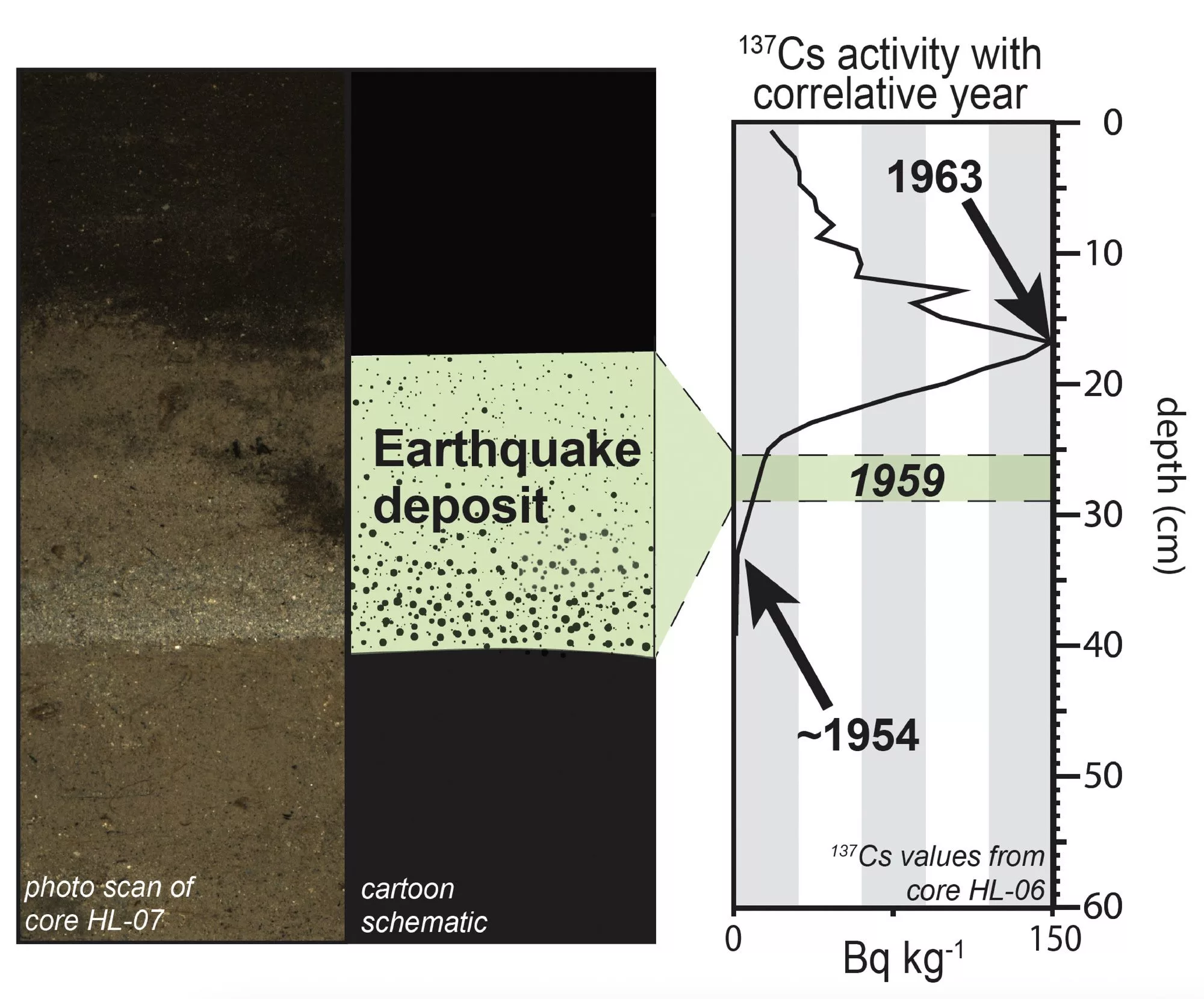
A common signature of earthquake disturbance within sediment cores results from sediment failure of the lake margin, transport downslope, and deposition in central areas of the lake basin. Cores from multiple locations in Henrys Lake contained a thin (2 inch), distinct, gray sandy layer in their upper portion that appeared to be a record of a recent earthquake.
The challenge was then to test if this layer matched the timing of the 1959 earthquake.
This was done by measuring the concentration of the chemical component Cesium-137 (137Cs) with depth. 137Cs was produced during atmospheric nuclear testing in the mid-20th century, so the concentration in sediment can be matched with the known frequency of nuclear testing through time to establish the age of the sediment layer.
For example, above ground nuclear testing increased around 1954, and the concentration of 137Cs in sediments starts to grow from undetectable levels to detectable that year. Conversely, the Nuclear Test Ban Treaty was signed in 1963, so sediment of this age has peak 137Cs concentration that drastically drops immediately thereafter (which is toward the top of the core in the most recently deposited sediment).
These defined concentration levels should essentially bound the 1959 earthquake deposit in the sedimentary record!
So, what about that outstanding layer of sand hypothesized to be associated with the 1959 earthquake? When pairing the 137Cs concentration data with the sedimentological data, we found that the sand deposit was indeed bracketed between 1954 and 1963, providing solid evidence that this layer probably formed during the 1959 Hebgen Lake earthquake.
With evidence that sediment at the bottom of Henrys Lake does, indeed, contain records of past earthquakes, the next goal was to look for other prehistoric earthquakes using the 1959 Hebgen Lake deposit as a reference.
However, there were no such similar deposits with the same sediment character and presence in multiple cores. Using radiocarbon dating techniques, we were able to establish that the very lowest portions of the cores were approximately 5,000 years old.
Does this mean that there have not been earthquakes similar in intensity to the Hebgen Lake earthquake in the last 5,000 years? Not exactly.
The lowermost layer of the cores — the 5,000-year-old layer — is consistent with deposits from a marshy wetland, not a lake at all! Marshy wetlands are saturated areas with a lot of plants and grasses that typically produce organic-rich soils and not finely layered sediment like lakes do, making them much less likely to record an earthquake.
Based on estimates of sedimentation rate, it appears that Henrys Lake likely only changed from a marshy wetland to a shallow lake less than about 1,000 years ago.
Although there is a lot more to explore about the specific evolution of Henrys Lake and other lakes in the west Yellowstone area, it is promising that a shallow lake with gentle sloping margins can record earthquake shaking. These findings provide increased confidence in our ability to investigate shaking-related deposits in other lakes with similar characteristics in the Rocky Mountain region or beyond.
Idaho Capital Sun is part of States Newsroom, a nonprofit news network supported by grants and a coalition of donors as a 501c(3) public charity. Idaho Capital Sun maintains editorial independence. Contact Editor Christina Lords for questions: info@idahocapitalsun.com.