KEY MESSAGES:
Strong winds on the fire led to two small spot fires on the northeast side of the fire. . These spot fires merged as firefighters engaged. Hand crews dug line and placed hose line around the perimeter. Due to favorable visibility and light winds, air operations began bucket drops earlier yesterday than in previous days. The spot fire is now contained with a perimeter of 1.5 acres. Aviation resources were utilized in tandem with firefighters on the ground to aggressively engage the fire.
CURRENT STATUS:
On the southern end of Cougar Creek Fire, structure protection continues around Grouse Flats. Crews are patrolling current control lines from Wenatchee Creek drainage, west towards the 40 Road. Hand crews continue to mop up in this area in and around the fire edge.
An indirect line on Mallory Ridge has been completed to enhance contingency efforts. Crews have been making progress on mop-up operations and continue to patrol the southern portion of Hansen Ridge.

FIRE BEHAVIOR AND WEATHER:
Yesterday evening, the fire area received some rain, amounting to five-hundredths of an inch. This moisture helped slow fire progression but was not substantial enough for long-term beneficial effects. Today, an eastern wind will build higher pressure over the area, which will foster higher than average temperatures and lower relative humidities later in the week. This instability may promote active fire behavior.
EVACUATIONS AND CLOSURES:
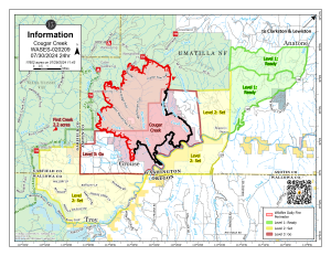
Forest closure descriptions and maps are available online on the Umatilla National Forest Closure page. In Washington, evacuation notices are posted on the Asotin County Sheriff web page and Asotin County Emergency Management Facebook page. Grande Ronde Road is closed from Troy, Oregon to Highway 129 junction in Washington. In Oregon, a level 2 evacuation is in effect for Wallowa County, including all of Grouse Flat from Bear Creek Rd north to the State boundary and the Garfield County line to Grande Ronde River. 07.30.2024 Cougar Creek Update


