Connect with us

Hi, what are you looking for?

Advertisements
DailyflyDailyfly

Idaho State News

Idaho Statewide Fire Update – 9/7/2024

September 7, 2024

Statewide Fire Update

This report is published weekly during fire season and covers the fire situation on land protected by the Idaho Department of Lands, Clearwater-Potlatch Timber Protective Association (CPTPA), or the Southern Idaho Timber Protective Association (SITPA), current fire statistics, the status of major fires and fire restrictions.

Use these links to jump to a section:


IDL Fire Situation

IDL Protection Only as of Sept. 3, 2024

Total Acres Burned, Year to Date*
  • 27,983 Acres
Total Number of Fires, Year to Date
  • 271 Fires
Total Human-Caused Fires, Year to Date
  •  121 Human-Caused 
  •  53 Undetermined
  •  104 Natural 

*Acres reflect what has burned within the IDL protection area and do not reflect ownership.

(RETURN TO TOP OF PAGE)


IDL Fire Suppression Expenses

As of Monday, September 3, 2024, IDL has spent a total of approximately $39.7 million on fire suppression activities. Approximately $3.5 million of that is reimbursable to IDL for assisting other agencies on their fires, leaving a total estimated net obligation to the General Fund of $36 million so far this year.

(RETURN TO TOP OF PAGE)


Statewide Acres Burned by Ownership

SURFACE OWNER ACRES
Idaho Department of Lands 28,200
Other State Lands 2936
Private 102,588
Bureau of Land Management 200,226
Forest Service 282,900
Other Federal 8587
Tribe 909
Undetermined 1018
Total Acres  627,364

(RETURN TO TOP OF PAGE)

Current as of August 30, 2024


Status of Major Fires on IDL Protection

The Chimney Fire started Sep. 2, 2024, on Idaho State Lands approximately 9 miles northwest of Fairfield, Idaho. IDL is assisting with InciWeb updates:  https://inciweb.wildfire.gov/incident-information/ideix-chimney-fire

(RETURN TO TOP OF PAGE)


IDL Incident Management Team Fires to Date

Flat Fire

  • The Southwest Forest Protective District received management of the fire on August 8. Management was transferred to the North Idaho Gold Team on August 16. On August 19 the Great Basin Complex Incident Management Team 6 assumed command of the fire. The management was returned to the district on Tuesday August 27. The final acreage for the fire was 3,732 acres. 

Gwen Fire

  • Ponderosa Forest Protective District/Nez Perce Tribe transferred management to the Rocky Mountain Complex Incident Management Team Three (Bill Wall I.C.) on July 28. The fire was transferred back to local managers on Saturday, August 3.The final acreage for the fire was 28,820 acres.

Cherry Fire/Steelhead Fire

  • Craig Mountain Forest Protective District transferred management to the IDL Type 3 Team (Nate Rogers I.C. and Graydon Galloway IC3 trainee) on July 30. Management was transferred back to the district on August 2. Cherry Fire was 53 acres and the Steelhead Fire was 59 acres.

Texas Fire

  • Ponderosa Forest Protective District transferred management to an Northern Rockies Team 8 on July 18. Management was transferred back to the district on Thursday, July 25. The fire was 1,565 acres.

Billy Creek Fire

  • Craig Mountain Forest Protective District transferred management to the Northern Rockies Team 1 (Brent Olson I.C.) on July 7. Management transferred back to the district on Friday, July 12. The fire was 3,185 acres.

(RETURN TO TOP OF PAGE)


Status of Select Fires Outside IDL Protection

For full Idaho fire details visit https://inciweb.wildfire.gov/ 


Middle Fork Complex

Agency/Management: Boise National Forest
General Location: 9 miles east of Garden Valley
Acres Burned:  58,351 acres
Cause: Lightning
Containment: 29%
Personnel: 773
Inciweb: https://inciweb.wildfire.gov/incident-information/idbof-middle-fork-complex-fire-bulldog-and-nellie

Snag Fire

Agency/Management: Boise National Forest
General Location: 9.5 miles east of Cascade
Acres Burned: 32,630 acres
Cause: Lightning
Containment: 13%
Personnel: 432
Inciweb: https://inciweb.wildfire.gov/incident-information/idbof-snag-fire

Dollar Fire

Agency/Management: Boise National Forest
General Location: 18 miles northeast of Cascade
Acres Burned: 4,199 acres
Cause: Lightning
Containment: 8%
Personnel: 15
Inciweb: https://inciweb.wildfire.gov/incident-information/idbof-dollar-fire

Wapiti Fire

Agency/Management: Boise National Forest
General Location: 2 miles southwest of Grandjean
Acres Burned: 114,945 acres
Cause: Lightning
Containment: 12%
Personnel: 1,565
Inciweb: https://inciweb.wildfire.gov/incident-information/idbof-wapiti-fire

Boulder Fire

Agency/Management: Boise National Forest
General Location: 9 miles southwest of Cascade
Acres Burned: 4,055 acres
Cause: Lightning
Containment: 24%
Personnel: 479
Inciweb: https://inciweb.wildfire.gov/incident-information/idbof-boulder-fire

Goat Fire

Agency/Management: Boise National Forest
General Location: 11 miles SE of Cascade, Idaho
Acres Burned: 4,910 acres
Cause: Lightning
Containment: 0%
Personnel: 83
Inciweb: https://inciweb.wildfire.gov/incident-information/idbof-goat-fire

Wolf Creek Fire

Agency/Management: Payette National Forest
General Location: 11 Miles NW of Cascade, ID
Acres Burned: 1,154 acres
Cause: Lightning
Containment: 100%
Personnel: 65
Inciweb: https://inciweb.wildfire.gov/incident-information/idpaf-wolf-creek-fire

Limepoint Fire

Agency/Management: Payette National Forest
General Location: 8 miles northeast of Oxbow Dam
Acres Burned: 33,016 acres
Cause: Lightning
Containment: 95%
Personnel: 174
Inciweb: https://inciweb.wildfire.gov/incident-information/idpaf-limepoint-fire

Payette Wilderness Fires

Includes Coxie Hole, Grizzly Fire, and Quartz fires.

Agency/Management: Payette National Forest
General Location: Frank Church River of No Return Wilderness
Acres Burned: Refer to https://inciweb.wildfire.gov/incident-information/idpaf-payette-wilderness-fires
Cause: Refer to https://inciweb.wildfire.gov/incident-information/idpaf-payette-wilderness-fires
Containment: Refer to https://inciweb.wildfire.gov/incident-information/idpaf-payette-wilderness-fires
Personnel: Refer to https://inciweb.wildfire.gov/incident-information/idpaf-payette-wilderness-fires
Inciweb: https://inciweb.wildfire.gov/incident-information/idpaf-payette-wilderness-fires

Burnt Creek Fire

Agency/Management: Payette National Forest
General Location: Frank Church River of No Return
Acres Burned: 2666 acres
Cause: unknown
Containment: unknown
Personnel: 0
Inciweb: https://inciweb.wildfire.gov/incident-information/idpaf-burnt-creek-fire

Farrow Fire

Agency/Management: Payette National Forest
General Location: Frank Church River of No Return
Acres Burned: 900 acres
Cause: unknown
Containment: unknown
Personnel: 0
Inciweb: https://inciweb.wildfire.gov/incident-information/idpaf-farrow-fire

Parks Fire

Agency/Management: Payette National Forest
General Location: Frank Church River of No Return
Acres Burned: 3,850 acres
Cause: unknown
Containment: unknown
Personnel: 0
Inciweb: https://inciweb.wildfire.gov/incident-information/idpaf-parks-fire

Cracker Jack Complex

Agency/Management: Nez Perce – Clearwater National Forests
General Location: All four fires are located within half a mile of each other: two and a half miles east of Concord
Acres Burned: 3,800 acres
Cause: Lightning
Containment: 0%
Personnel: 65
Inciweb: https://inciweb.wildfire.gov/incident-information/idncf-cracker-jack-complex

(RETURN TO TOP OF PAGE)


Statewide Fire Map

Statewide Fire Map Cover Image This GIS-enabled Statewide Fire Map uses data from the Integrated Reporting of Wildland-Fire Information (IRWIN) system.  Unlike other online fire information webpages or databases, such as Inciweb, which may only report on incidents that threaten structures or cover large acreages, this fire map displays information about all reported wildfires in Idaho.

(RETURN TO TOP OF PAGE)


Fire Restriction Information

Fire Restrictions Finder Cover Page IDL’s Fire Restriction Finder webpage includes a GIS-enabled map that highlights fire restrictions announced by the responsible jurisdictions.  It also includes helpful definitions of Stage 1 and 2 restrictions, along with answers to Frequently Asked Questions.


Visit the Fire Restriction Finder Webpage

Fire Restrictions Currently in Place

Idaho has been divided into eight Fire Restriction Areas with zones established within. Each area corresponds with the fire dispatch area boundaries. Interagency coordination between fire management agencies with the areas are used to
initiate restrictions. This helps provide consistency among the land management partners, while defining the restriction boundaries so they are easily distinguishable to the public.

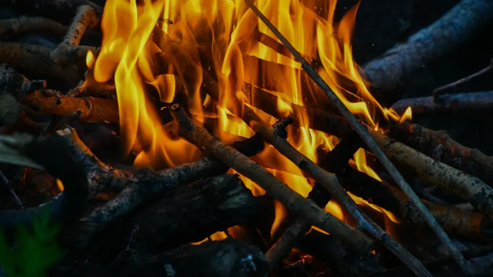
The purpose of fire restrictions is to reduce the risk of human-caused fires during unusually high fire danger and/or burning conditions, and when other prevention efforts have been exhausted.

The following areas are in Stage 1 fire restrictions that include all lands managed by or are under the fire protection of Idaho Department of Lands, Bureau of Land Management, the Forest Service, or other tribal or federal agencies.

Sawtooth North (National Forest),Cassia Zone (National Forest)

Boise – West Central Mountain zone

Stage 1 restrictions prohibit:

  • Building, maintaining, attending to, or using a fire, campfire, charcoal grill or stove fire, except within a designated recreation site, and only within a fire structure provided by the administrative agency or landowner.
  • Smoking, except within an enclosed vehicle, building or designated recreation site, or while stopped in an area at least 3 feet in diameter that is barren or cleared of all flammable materials.

Online Fire Restriction Resources

(RETURN TO TOP OF PAGE)


Fire Outlook

Northern Rockies Coordination Center Outlooks (North Idaho):

Great Basin Coordination Center Outlooks (Southern Idaho):

Advertisements
Advertisements

Obituaries

Sandra Kinney September 5, 2024

Local News

(Lewiston, ID) The 2024 Lewiston’s 90th annual Roundup Parade will be held tomorrow, Saturday September 7.  Line up begins at 7:59 am. The parade...