The Williams Creek Fire, 5 miles west of Orogrande, has grown to 16,084 acres and is 31% contained. The Forest implemented an expanded Area Closure on 9/12, due to the fire’s location and its high potential for movement given the dry fuels and recent weather conditions. The closure remains in effect and will be re-evaluated, based on fire activity conditions and associated firefighting efforts.
Crews dismantled the pumps and water-handling equipment from Wild Horse Lake yesterday. Crews to the north of the fire and in Orogrande also worked on removing equipment no longer needed. Excess resources not needed will demobilize.
Sampson’s Incident Management Team will work to transition with resources remaining on the fire, ensuring a smooth transfer of command on Saturday morning.
Aerial support from helicopters was unavailable yesterday due to low visibility. An unmanned aerial system (“drone”) was able to fly the fire area. Drone activities were slightly hampered by gusty winds, rain, and small hail.
However, drone operators could still successfully monitor fire activity along the northern flank and gather information on the fuels treatment project areas west of Orogrande.
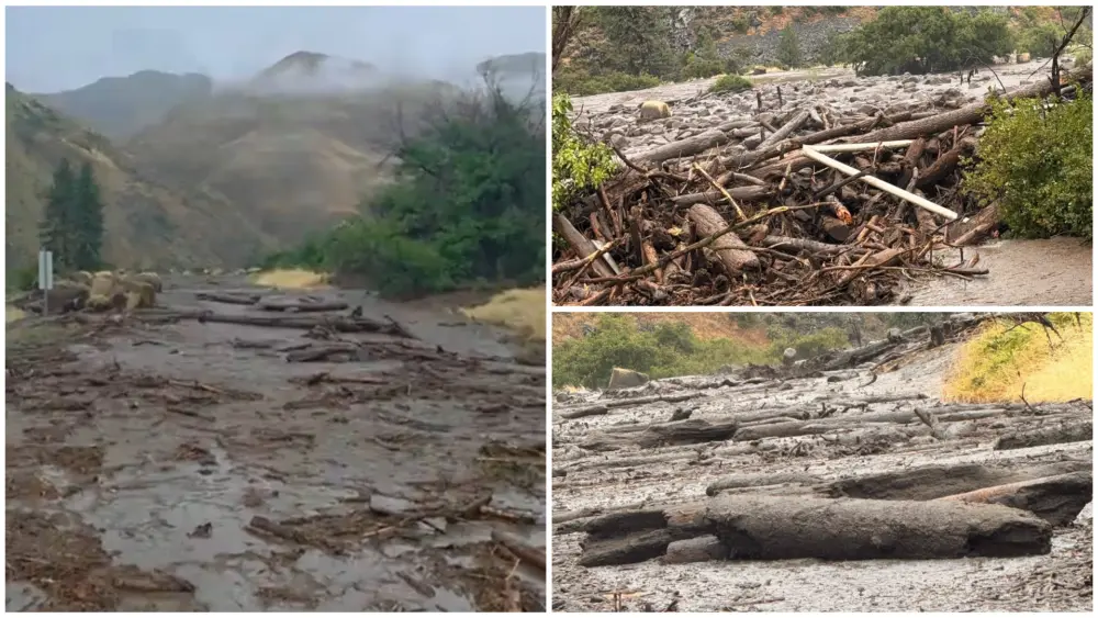
As the fire continues to smolder along the 233 and 311 Roads, standing dead trees (“snags”) remain a dangerous hazard and could fall without notice. Crews and heavy equipment are working to remove these trees and clear the roadways, coordinating with the county road department to determine necessary repairs. The roads into Orogrande remain closed to the general public, as this area is within the Forest Area Closure.
The Twin Lakes Fire, east of Twin Lakes and Hagen Creek, is 992 acres and 40%, however, it will be monitored by local Forest Service resources, as needed, beginning today. The wildfire module completed structure protection measures and has been demobilized.
WEATHER AND FIRE BEHAVIOR
The northern portion of the fire received about a half inch of rain and some small-sized hail yesterday. The southern side of the fire did not receive any wetting rain. Humidity levels ranged from the high 40s to low 70s, with temperatures topping out
in the mid-60s. Similar weather is expected today, with more widespread rain. The entire fire area could see between a quarter to a half inch of rain over the course of the day. This cool, wet weather pattern is likely to remain through the weekend.
Snowfall in higher elevations is possible by early next week. Due to the weather, limited fire behavior is expected.
However, smoke will likely remain visible as larger fuels continue to smolder in the interior of the fire area.
CLOSURES AND SPECIAL MESSAGES
Closures surrounding both fire areas are necessary to protect the safety and welfare of the public and provide for safe firefighting efforts and access. Specific closure information and maps are posted on Inciweb at https://inciweb.nwcg.gov/incident/8372/ as they are implemented.
The Twin Lakes Fire closure includes the following roads and trails:
OPEN:
NFSR 444 Gospel Road – open from junction with NFSR 221 to Moore’s Guard Station/Campground
CLOSED:
NFST 312 – North Moore’s Trail – closed from trailhead to MP 6.83/jct with NFST 383 Square Mountain
NFST 383 – Square Mountain Trail – closed from MP 6.64/jct with NFST 315 to MP 7.16/jct with NFST 312
NFST 315 – Kentucky Creek Trail – closed from trailhead/jct with NFST 313 to MP 7.71/jct with NFST 383
NFST 313 – Hump Trail – closed from MP 15.4/jct with NFST 384 to MP 18.1/jct with NFST 315
NFST 384 – Square Mtn. Spur Trail – closed from trailhead/jct with NFST 383 to MP 1.37/jct with NFST 313
NFST 383 – Square Mountain Trail – closed from trailhead/jct with NFSR 444 to MP 1.59/jct with NFST 384
NFSR 444 – Gospel Road – closed from MP 11.57 at Moore’s Campground to end of road at Square Mountain Lookout
The Williams Creek Fire closure includes the following roads and trails:
OPEN:
Idaho Highway 14 – South Fork Highway: Open from MP 35.2 to MP 43 at Elk City Township Boundary. NFSR 222 –
Dixie Road: Open from Forest Boundary at MP 0.95 to jct with NFSR 1800 at MP 7.36.
CLOSED:
NFSR 1800 – 66 Creek Road: Closed from junction with NSFR 222 to jct with NSFR 9803.
NFSR 9803 – North Wheeler Mtn. Road: Closed from jct with NSFR 1800 to jct with NSFT 508.
NFST 508 Porter Trail: Closed from jct with NSFR 9803 to jct with NSFT 207.
NFST 207 Moose Butte Trail: Closed from jct with NST 508 to hydrologic divide located in T26N R8E section 9 NW 1/4.
NFST 205 Columbia Ridge Trail: Closed from hydrologic divide/ridge located in T26N R8E section 20 NW 1/4. to junction
with NSFR 233 near Orogrande Summit.
NFSR 233 Crooked River Road: Closed from jct with NSFT 205 to jct with NSFR 233C.
NFSR 233C Little Buffalo Road: Closed from jct with NSFR 233 to jct with NSFT 313.
NFST 313 Hump Trail: Closed from jct with NSFR 233C to jct with NSFT 300.
NFST 300 Boundary Peak Trail: Closed from jct with NSFT 313 to hydrologic divide/ridge located in T27N R6E section 17
NW 1/4.
NFST 806 20 Mile Lake Trail: Closed from hydrologic divide/ridge located in T27N R6E section 5 NW 1/4 to jct with
NSFT 414.
NFST 414 20 Mile Creek Trail: Closed from jct with NSFT 806 to jct with NSFT 930.
NFST 930 Desperation Mine Trail: Closed from jct with NSFT 414 to jct with NSFR 492.
NFSR 492 Santiam Sourdough Road: Closed from jct with NSFT 930 to beginning of road/junction with Idaho Hwy 14.
- “Percent completion” of objectives more accurately captures and reports the specific amount of work accomplished on the
ground to manage fire spread and reduce the negative impacts to communities, infrastructure, and other identified values. By
using percent completion of objectives, fire managers can illustrate how they are progressing with the accomplishment of
objectives that have been identified and prioritized. As a comparison, “containment” implies firelines around the entire
perimeter, directly next to the fire’s active edge.
** Increases in acreage are due to better mapping over a three-day period. Infrared mapping flights were unable to fly due to
weather and visibility issues.
WILLIAMS CREEK FIRE (5 miles west of Orogrande)
Start Date: 8/29/2022 Cause: Lightning ** Size: 16,084 acres * Completion: 31%
Total Personnel: 150 Engines: 5 Helicopters: 2 Hand Crews: 2
The Forest implemented an expanded Area Closure on 9/12, due to the fire’s location and its high potential for
movement given the dry fuels and recent weather conditions. The closure remains in effect and will be re-evaluated,
based on fire activity conditions and associated firefighting and efforts.
Crews dismantled the pumps and water-handling equipment from Wild Horse Lake yesterday. Crews to the north of the fire
and in Orogrande also worked on removing equipment no longer needed. Excess resources not needed will demobilize.
Sampson’s Incident Management Team will work to transition with resources remaining on the fire, ensuring a smooth
transfer of command on Saturday morning.
Aerial support from helicopters was unavailable yesterday due to low visibility. An unmanned aerial system (“drone”) was
able to fly the fire area. Drone activities were slightly hampered by gusty winds, rain, and small hail. However, drone
operators were still successfully able to monitor fire activity along the northern flank and gather information on the fuels
treatment project areas west of Orogrande.
As the fire continues to smolder along the 233 and 311 Roads, standing dead trees (“snags”) remain a dangerous hazard and
could fall without notice. Crews and heavy equipment are working to remove these trees and clear the roadways,
coordinating with the county road department to determine necessary repairs. The roads into Orogrande remain closed to the
general public, as this area is within the Forest Area Closure.
TWIN LAKES FIRE (east of Twin Lakes and Hagen Creek)
Start Date: 8/25/2022 Cause: Lightning ** Size: 992 acres * Completion: 40%
The Twin Lakes Fire will be monitored by local Forest Service resources, as needed, beginning today. The wildfire module
completed structure protection measures and has been demobilized.
WEATHER AND FIRE BEHAVIOR
The northern portion of the fire received about a half inch of rain and some small-sized hail yesterday. The southern side of
the fire did not receive any wetting rain. Humidity levels ranged from the high 40s to low 70s, with temperatures topping out
in the mid-60s. Similar weather is expected today, with more widespread rain. The entire fire area could see between a
quarter to a half inch of rain over the course of the day. This cool, wet weather pattern is likely to remain through the
weekend. Snowfall in higher elevations is possible by early next week. Due to the weather, limited fire behavior is expected.
However, smoke will likely remain visible as larger fuels continue to smolder in the interior of the fire area.
CLOSURES AND SPECIAL MESSAGES
Closures surrounding both fire areas are necessary to protect the safety and welfare of the public and provide for safe
firefighting efforts and access. Specific closure information and maps are posted on Inciweb at
https://inciweb.nwcg.gov/incident/8372/ as they are implemented.
The Twin Lakes Fire closure includes the following roads and trails:
OPEN:
NFSR 444 Gospel Road – open from junction with NFSR 221 to Moore’s Guard Station/Campground
CLOSED:
NFST 312 – North Moore’s Trail – closed from trailhead to MP 6.83/jct with NFST 383 Square Mountain
NFST 383 – Square Mountain Trail – closed from MP 6.64/jct with NFST 315 to MP 7.16/jct with NFST 312
NFST 315 – Kentucky Creek Trail – closed from trailhead/jct with NFST 313 to MP 7.71/jct with NFST 383
NFST 313 – Hump Trail – closed from MP 15.4/jct with NFST 384 to MP 18.1/jct with NFST 315
NFST 384 – Square Mtn. Spur Trail – closed from trailhead/jct with NFST 383 to MP 1.37/jct with NFST 313
NFST 383 – Square Mountain Trail – closed from trailhead/jct with NFSR 444 to MP 1.59/jct with NFST 384
NFSR 444 – Gospel Road – closed from MP 11.57 at Moore’s Campground to end of road at Square Mountain Lookout
The Williams Creek Fire closure includes the following roads and trails:
OPEN:
Idaho Highway 14 – South Fork Highway: Open from MP 35.2 to MP 43 at Elk City Township Boundary. NFSR 222 –
Dixie Road: Open from Forest Boundary at MP 0.95 to jct with NFSR 1800 at MP 7.36.
CLOSED:
NFSR 1800 – 66 Creek Road: Closed from junction with NSFR 222 to jct with NSFR 9803.
NFSR 9803 – North Wheeler Mtn. Road: Closed from jct with NSFR 1800 to jct with NSFT 508.
NFST 508 Porter Trail: Closed from jct with NSFR 9803 to jct with NSFT 207.
NFST 207 Moose Butte Trail: Closed from jct with NST 508 to hydrologic divide located in T26N R8E section 9 NW 1/4.
NFST 205 Columbia Ridge Trail: Closed from hydrologic divide/ridge located in T26N R8E section 20 NW 1/4. to junction
with NSFR 233 near Orogrande Summit.
NFSR 233 Crooked River Road: Closed from jct with NSFT 205 to jct with NSFR 233C.
NFSR 233C Little Buffalo Road: Closed from jct with NSFR 233 to jct with NSFT 313.
NFST 313 Hump Trail: Closed from jct with NSFR 233C to jct with NSFT 300.
NFST 300 Boundary Peak Trail: Closed from jct with NSFT 313 to hydrologic divide/ridge located in T27N R6E section 17
NW 1/4.
NFST 806 20 Mile Lake Trail: Closed from hydrologic divide/ridge located in T27N R6E section 5 NW 1/4 to jct with
NSFT 414.
NFST 414 20 Mile Creek Trail: Closed from jct with NSFT 806 to jct with NSFT 930.
NFST 930 Desperation Mine Trail: Closed from jct with NSFT 414 to jct with NSFR 492.
NFSR 492 Santiam Sourdough Road: Closed from jct with NSFT 930 to beginning of road/junction with Idaho Hwy 14.
- “Percent completion” of objectives more accurately captures and reports the specific amount of work accomplished on the
ground to manage fire spread and reduce the negative impacts to communities, infrastructure, and other identified values. By
using percent completion of objectives, fire managers can illustrate how they are progressing with the accomplishment of
objectives that have been identified and prioritized. As a comparison, “containment” implies firelines around the entire
perimeter, directly next to the fire’s active edge.
** Increases in acreage are due to better mapping over a three-day period. Infrared mapping flights were unable to fly due to
weather and visibility issues.