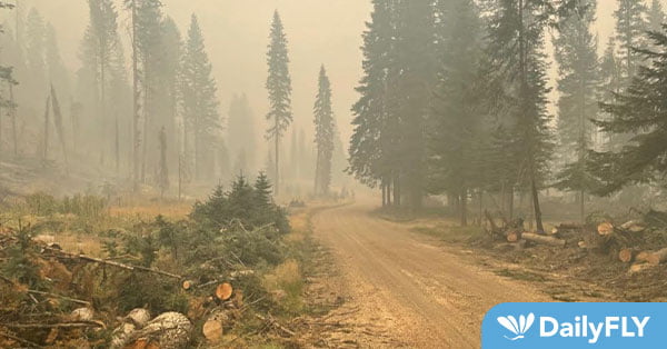
The Williams Creek Fire that is five miles west of Orogrande is now sized at 15,773 and 15% contained. The Idaho County Sheriff’s Office rescinded the “Level 3-GO” evacuation notice for the community of Orogrande, however, the Forest Area Closure remains in effect.
A road/security checkpoint will be present at the junction of the Crooked Creek and Deadwood Roads. As the fire continues to smolder along the 233 and 311 Roads, standing dead trees (“snags”) remain a dangerous hazard and could fall without notice. Crews and heavy equipment are working to remove these trees and clear the roadways. The roads into Orogrande remain closed to the public, as the Forest Area Closure is still in effect.
Resources will continue to engage the fire in Orogrande and the Crooked River corridor, extinguishing hot spots and securing properties. Crews continue to assess structure protection needs in the Red River Valley, should the fire progress toward that area.
Aerial resources will be available to assist crews today, weather permitting. An overnight infrared flight mapped the fire at 15,773 acres. This increase in acreage reflects better mapping, rather than substantial fire perimeter growth and progression. The fire had limited growth along the northeast corner and western flank.
The Twin Lakes Fire east of Twin Lakes and Hagen Creek is now around 973 acres and is 19% contained.
Crews completed structure protection at Moore’s Guard Station. The structure protection module will continue to secure structures in the area and “mop up” residual heat in the burn area. As crews complete more of their objectives, resources will likely be demobilized or repositioned to the Williams Creek Fire later in the week.
An overnight infrared flight mapped the fire at 973 acres.
An inversion and thick drift smoke from adjacent fires provided shading from strong solar radiation. Temperatures remained in the 80s and relative humidity levels dipped into the low teens with poor relative humidity recoveries overnight.
Tomorrow’s weather forecast is similar, with light winds and warm, dry conditions. Storms bringing moisture to the area will result in relative humidity levels in the 30% range. There is a good chance of widespread wetting rain before Friday. Fire behavior will likely remain static, with mostly creeping and smoldering. Limited perimeter growth is expected. If the inversion from drift smoke lifts or the sun is able to penetrate the inversion, active fire behavior is more likely.
The Williams Creek fire may see increased activity to the north along the ridgeline and to the east in interior pockets of unburned fuels.
Closures surrounding both fire areas are necessary to protect the safety and welfare of the public and provide for safe firefighting efforts and access. Specific closure information and maps are posted on Inciweb at https://inciweb.nwcg.gov/incident/8372/ as they are implemented.
The Twin Lakes Fire closure includes the following roads and trails:
OPEN:
NFSR 444 Gospel Road – open from junction with NFSR 221 to Moore’s Guard Station/Campground
CLOSED:
NFST 312 – North Moore’s Trail – closed from trailhead to MP 6.83/jct with NFST 383 Square Mountain
NFST 383 – Square Mountain Trail – closed from MP 6.64/jct with NFST 315 to MP 7.16/jct with NFST 312
NFST 315 – Kentucky Creek Trail – closed from trailhead/jct with NFST 313 to MP 7.71/jct with NFST 383
NFST 313 – Hump Trail – closed from MP 15.4/jct with NFST 384 to MP 18.1/jct with NFST 315
NFST 384 – Square Mtn. Spur Trail – closed from trailhead/jct with NFST 383 to MP 1.37/jct with NFST 313
NFST 383 – Square Mountain Trail – closed from trailhead/jct with NFSR 444 to MP 1.59/jct with NFST 384
NFSR 444 – Gospel Road – closed from MP 11.57 at Moore’s Campground to end of road at Square Mountain Lookout
The Williams Creek Fire closure includes the following roads and trails:
CLOSED:
NFSR 233 – Crooked River Road – closed from jct with NFSR 522 to jct with NFSR 233I at Orogrande Summit
NFSR 492 – Santiam Sourdough Road – closed from jct with trail 415 to jct with trail 416
NFSR 233I – Wild Horse Campground Road – closed from jct with NSFR 233 to end of road
NFST 299 – Crystal Lake Trail – closed from TH /jct with NSFR 233I to jct with trail 803 at MP 2.04
NFST 803 – Ten Mile Spur – closed from TH/jct with Trail 299 to end of trail/jct with Trail 415
NFST 415 – Ten Mile Trail – closed from TH/junction with Trail 803 at MP 6.49 to TH/jct with NFSR 492
NFST 416 – Old Golden-North Hill Trail – closed from TH/jct with NSFR 492 to end of trail jct with NSFR 478A.
NFSR 478A – Forest Road 478A – closed from jct with Trail 416 at 0.2 to jct with NSFR 478
NFSR 478 – Nipple Mountain Road – closed from jct with NSFR 478A at MP 1.56 to jct with Trail 807 at MP 1.65
NFST 807 – Five Mile Trail – closed from end of trail/jct with NSFR 478 to TH/jct with NSFR 2003
NFSR 2003 – Five Mile camp Road – closed from jct with Trail 807 at MP 0.15 to beginning of road/jct with NSFR 233
“Percent completion” of objectives more accurately captures and reports the specific amount of work accomplished on the ground to manage fire spread and reduce the negative impacts to communities, infrastructure, and other identified values. By using percent completion of objectives, fire managers can illustrate how they are progressing with the accomplishment of objectives that have been identified and prioritized.
As a comparison, “containment” implies firelines around the entire perimeter, directly next to the fire’s active edge.