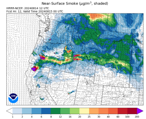
(KAMIAH, ID)— Fires in northern California, eastern Washington, and Oregon are producing smoke and haze across the region, which may impact the communities within and around the Nez Perce-Clearwater National Forests. More light smoke and haze will drift into South and North Idaho tomorrow morning before afternoon winds provide more limited dispersion. For more information regarding smoke and air quality, please visit the following links:
- Idaho Smoke Information- https://idsmoke.blogspot.com/
- Air Quality- https://fire.airnow.gov/
For information on current Nez Perce-Clearwater National Forests’ fires, please call the Nez Perce-Clearwater National Forests’ Fire Information Line, 208-935-6134, or check InciWeb for large fire updates, https://inciweb.wildfire.gov/.
Current Active Fires on the Nez Perce-Clearwater NF as of reporting time:
Salmon River Ranger District
Ace Butte Fire is a lightning-caused wildfire that was detected on July 24, 2024 and is located 22 ½ miles northeast of Riggins, ID. The fire is less than 100 acres. Minimal fire activity has occurred since last week’s update.
Anchor Fire is a lightning-caused wildfire that was detected on July 28, 2024 and is located approximately three miles north of the Ace Butte Fire, and about 23 ½ miles northeast of Riggins, ID. The fire is less than 100 acres. Minimal fire activity has occurred since last week’s update.
Red River Ranger District
Shepp Fire remains contained at this time.
Cracker Jack Complex is composed of four different lightning-caused wildfires burning in the Gospel-Hump Wilderness: The Square Lake Fire, Whistling Pig Fire, Fish Fire, and Fish 2 Fire. Together, the fires are approximately 89 acres. All four fires are located within half a mile of each other: two and a half miles east of Concord, ID, less than a quarter mile east from Square Lake and less than a quarter mile west from Fish Lake. A local Type 3 Incident Management Team is being assembled to take command of the fire.
At this time, there are no official closures, but fire management highly encourages the public to avoid the NFSR #311, due to firefighter resource and heavy equipment traffic going in and out of the area.
Moose Creek Ranger District
Wye Fire is a lightning-caused wildfire that was detected on July 25, 2024 and is located approximately four and a half miles northwest of Freeman Peak and seven miles northeast of the Moose Creek Airstrip. After a recent infrared flight, the fire is now approximately 4,500 acres and continues to burn primarily in a 2015 fire scar.
Roll Tide Fire is a lightning-caused wildfire that was detected on July 28, 2024 and is located 22 miles southeast of Lowell, ID and 14 miles southwest of the Moose Creek Airstrip. The fire remains approximately one acre.
Otter Fire is a lightning-caused wildfire that was detected on July 29, 2024 and is located approximately one mile north of the Roll Tide Fire, 22 1/2 miles southeast of Lowell, ID and 13 miles southwest of the Moose Creek Airstrip. The fire remains approximately two acres.
Ghost Fire is a lightning-caused wildfire that was detected on August 4, 2024 and is located about 11 ½ miles east of Lowell, ID and seven and a half miles southwest of Fenn Mountain. The fire is approximately 1/10th of an acre.
Crimson Fire is a lightning-caused wildfire that was detected on August 8, 2024, a is located about four and a half miles south of the Moose Creek Airstrip and about nine and a half miles northwest of Gardiner Peak Lookout. The fire is approximately 10 acres.
Twin Butte Fire is a lighting-caused wildfire that was detected on August 8, 2024, and is located one and a half miles north of Twin Butte and three and a half miles northwest of Elk Ridge. The fire is approximately one acre, and smoke has not been visible the last few days.
Pettibone Fire is a lightning-caused wildfire that was detected on August 8, 2024, and is located four and a half miles southeast of Freeman Peak, in between the Pettibone North Ridge and Pettibone South Ridge. The fire is approximately 1/10th of an acre. Smoke has not been visible from this fire. This will be the last report, unless significant fire activity occurs.
Meek Fire is a lighting-caused wildfire that was detected on August 12, 2024, and is located nine and a half miles southwest of the Moose Creek Airstrip and five and a half miles northwest of Wylies Peak. The fire is approximately a quarter of an acre. Smoke has not been visible since detection.
Lochsa Ranger District
Bowl Creek Fire is a lightning-caused wildfire that was detected on July 26, 2024 and is located four and a half miles southeast of Rocky Ridge and seven miles northwest of Highway 12. The fire is less than 1/10th of an acre, and no visible smoke has still not been seen since the last week of July.
Yakus Creek Fire is a lightning-caused wildfire that was detected on August 13, 2024 and is located less than half a mile southeast of the National Forest Service Road #514 (Yakus Creek Road) and four and a half miles north of Syringa, ID. The fire is approximately one acre. At this time, there are two Type 6 engines, one initial attack module, and one C-faller engaged in suppression actions. Over the past day and a half, a greater emphasis has been placed on mitigating large hazard trees in the area. As hazard trees are removed, allowing for safer engagement from firefighters, crews will begin implementing direct fireline construction and hose lays around the perimeter of the fire.
Powell Ranger District
Boulder Creek Fire is a lightning-caused wildfire that was detected on July 24, 2024 and is located ten miles north of the Powell Ranger Station and 12 miles west of Lolo Hot Springs. The fire is approximately 25 acres, with minimal fire activity reported this past week.
Grave Butte Fire remains contained at this time.
###

Smoke outlook map depicting the large amounts of smoke being produced are coming from fires in southern Idaho, Oregon, and northern California.
(Map provided by Idaho Department of Air Quality)


